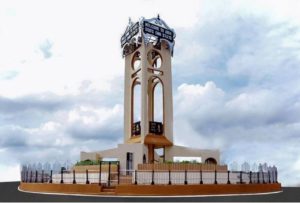
“Abia” is an acronym formed from the initial letters of four groups of people, namely: Aba, Bende, Isuikwuato and Afikpo. Abia State is a state in southeastern Nigeria created on 27 August, 1991 (Abia State was formed from part of Imo State), it borders Rivers State to the south, Ebonyi State to the north, Cross River State to the east and Imo State to the west. Its capital is Umuahia.
SEE ALSO: Abia State Post Offices: Full List & Address.
Abia State is nicknamed the “God’s Own State”.
Abia State Snapshot:
- Total land area: 4,900 Km2
- Capital: Umuahia
- Local Government Areas: 17 LGAs: Aba North, Aba South, Isiala Ngwa North, Isiala Ngwa South, Ukwa West, Ukwa East, Obingwa, Ikwuano, Bende, Arochukwu, Ohafia, Isuikwuato, Umuahia North, Umuahia South, Ugwunagbo, Osisioma and Nnochi.
- Population: 3,934,157 (Male- 2,006,420 and Female- 1,927,737)
- Vegetation: Tropical Rainforest and Savannah
- Major crops: Cocoa, Rice, Plantain, Maize, Cocoyam, Oil Palm, Cassava, Cashew, Rubber and Plantain.
- Solid minerals: Iron Ore, Kaolin, Limestone, and Gypsum.
Abia State Post Code / Zip Codes
Umuahia City Postal and Zip Codes
| Select LGA |
| Arochukwu |
| Abia North |
| Abia South |
| Bende |
| Ikwuano |
| Isiala Ngwa North |
| Isiala Ngwa South |
| Isukwuato |
| Obioma Ngwa |
| Ohafia |
| Osisioma |
| Ugwunagbo |
| Ukwa East |
| Ukwa West |
| Umunneochi |
Share: